Road safety and collision analysis software
Real-time, map-based collision data analysis solution designed for local authorities and road safety professionals.
Dashboards
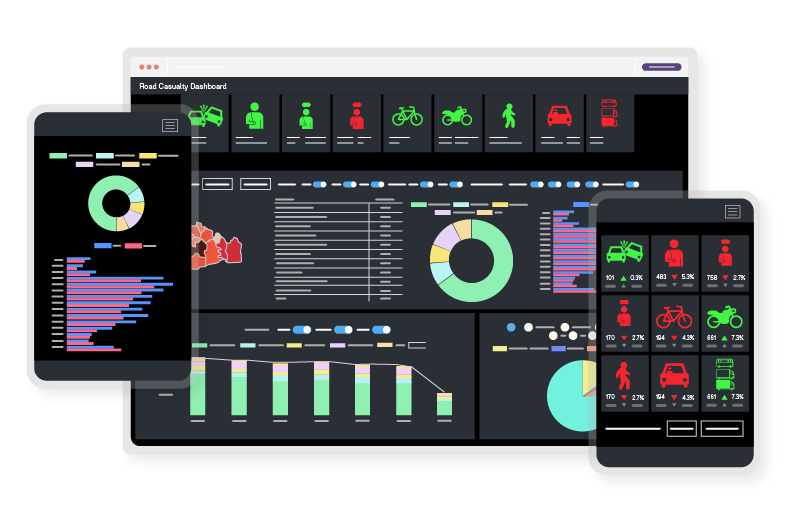
A series of road casualty Dashboards allows the sharing of key details in a clear and easy to understand manner, enabling non-specialists to interrogate data in an interactive way.
Download centre
Cloud service
A hassle-free environment that is the practical solution for your complete Infrastructure needs. Our ISO 27001 secure vetted private Cloud service is designed to facilitate work from home, as well as ensuring users are always kept abreast of the latest software releases. Accessing our collision analysis software Causeway AccsMap on the Cloud makes for a smooth experience
STATS19 and Connected Data
We understand the importance of data so, alongside STATS 19, we enable access to an ever expanding range of external data sets that fit perfectly with our software including: Super Output Areas, DfT’s Traffic Data, TAG values, and statistical information from the ONS on population, gender, age and deprivation.
Understand what's happening — and why
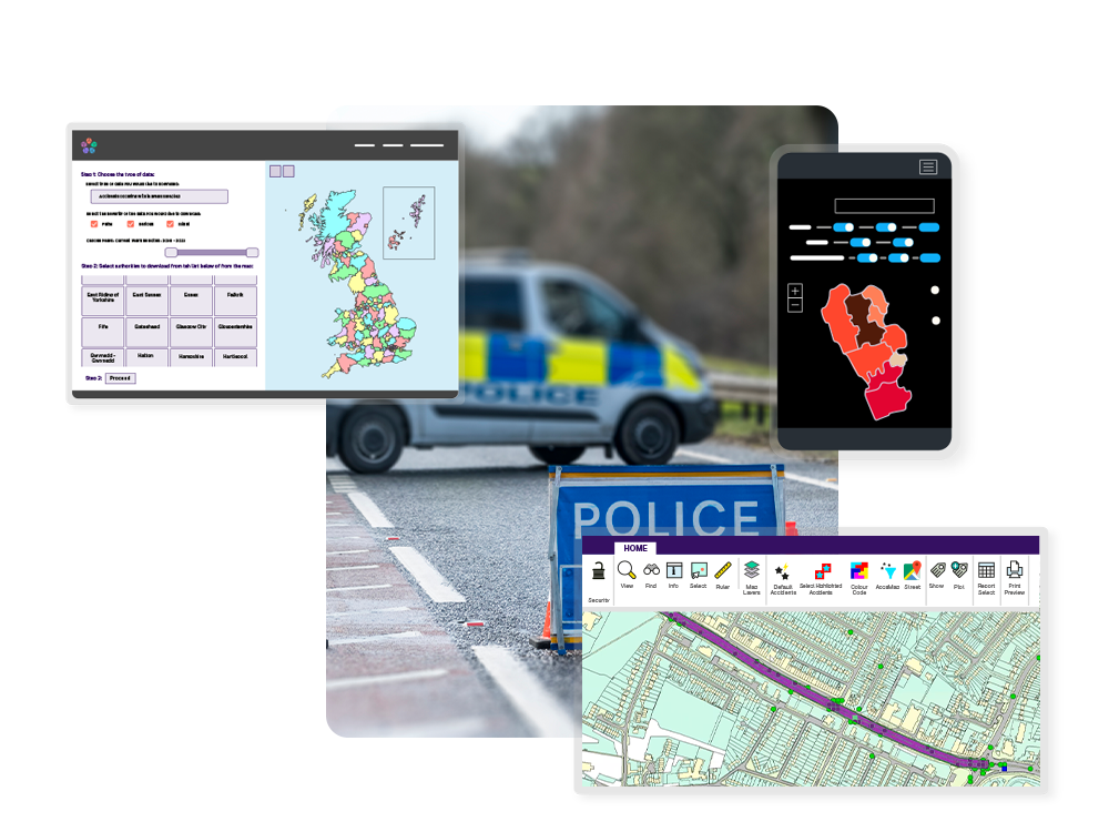
Causeway AccsMap is a powerful map-based road collision system which enables data to be viewed and interrogated on a map background so it can be analysed. Whether it is analysing specific sites, looking at regional trends, or carrying out comparative studies, Causeway AccsMap will provide the information needed to make knowledgeable decisions about road safety.
- Provides full STATS 21 validation with Department for Transport exports and the justification of safety camera sites.
- Powerful query and reporting routines take the analysis of collision data to the next level.
- AccsMap has a comprehensive set of analytical tools, including routing and cluster identification which are coupled with the ability to share information with partners and members of the public.
Everything local authorities need to analyse, report and share
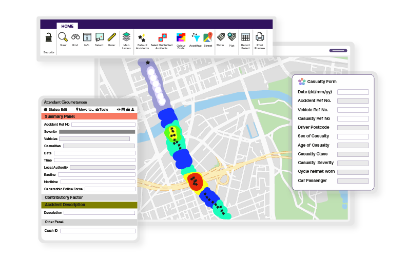
Our AccsMap application has been developed specifically to meet the needs of UK highways authorities and the police for a map-centred collision database and enquiry system.
It makes the complex three-tier structure of STATS19 data (accidents, vehicles and casualties) simple, allowing queries to be made at any level.
This means that local authorities can improve their ability to respond to safety concerns using a reliable database that provides easily accessible information on individual collisions and injuries as well as overall trends.
Road casualty dashboards
Our road casualty dashboards were created to make it easier for safety teams to share meaningful insights. Whether you’re preparing reports, setting strategy or engaging the public, these dashboards give you a clear, accessible view of key trends. All without needing to be a data expert.
- Helps teams and stakeholders track annual KSI casualty trends.
- Compare local figures with national data to monitor progress.
- Filter by area, year or type for tailored insights.
- Intuitive, interactive and easy for non-specialists to use.
Bring your collision data to life
Whether you need to update colleagues, consult with residents or inform local partners, Causeway makes it simple to share road safety data in a clear, engaging way.
- Support smarter decisions with shared insight: Show road safety trends in a way everyone can understand — from policymakers to the public
- Support smarter decisions with shared insight: Help partners and the public see the story behind the stats and work towards safer roads together.
- Save time answering public queries: Make road safety data accessible online so your team can focus on action, not admin.

The expert practitioner’s choice for collision analysis

Road safety teams
Pinpoint priority sites and track casualty trends.
Police services
Investigate incidents with high spatial accuracy.
Consultants and engineers
Support project design and evaluation with collision evidence.
Public communications
Use dashboards to improve transparency and engagement.


.jpg?width=768&height=886&name=BCP-Council-RGB-white-keyline%20(1).jpg)